Escalante National Monument
Back in May (when things seemed on the positive side of the virus and Utah was opening up) I went on a girls trip to Escalante National Monument for a couple days and did a lot of hiking. For those ready to get outside and explore this area, here’s what we did, what I would have changed, and my recommendations for enjoying the area to the fullest while being as cautious as possible.

Our itinerary
day 1 (Friday)
Left on a Friday afternoon from Provo, UT – 4 hour drive to Escalante, UT
Settled in at the Prospector Inn
day 2 (Saturday)
Woke up around 7am to get ready and get going
First hike: Lower Calf Creek Falls – 6.7 miles, flat and easy hike with beautiful waterfall at the end
Came back to Prospector Inn for lunch and rest
Second hike: Zebra Slot Canyon – 5.2 miles, easy hike but no shade, slot canyon is a very small part of the hike and is very narrow, only one way in and one way out
Got a much-needed meal at Circle D Eatery
day 3 (Sunday)
Hiked Peek-a-Boo Slot Canyon & Spooky Gulch
Visited Devils Garden (can make it a hike if you want)
Final dinner at Escalante Outfitters (ate it picnic-style in a nearby park — so good!)
Day 4 (Monday)
Went to Escalante Petrified Forest State Park ($10 day fee per vehicle)
Took the scenic route back to Provo
Things to be aware of
As mentioned above, Zebra is one way in, one way out – which made for a traffic jam and some frustrated people. Plus, with the virus, probably not the best if you’re trying to avoid being around strangers in a small area
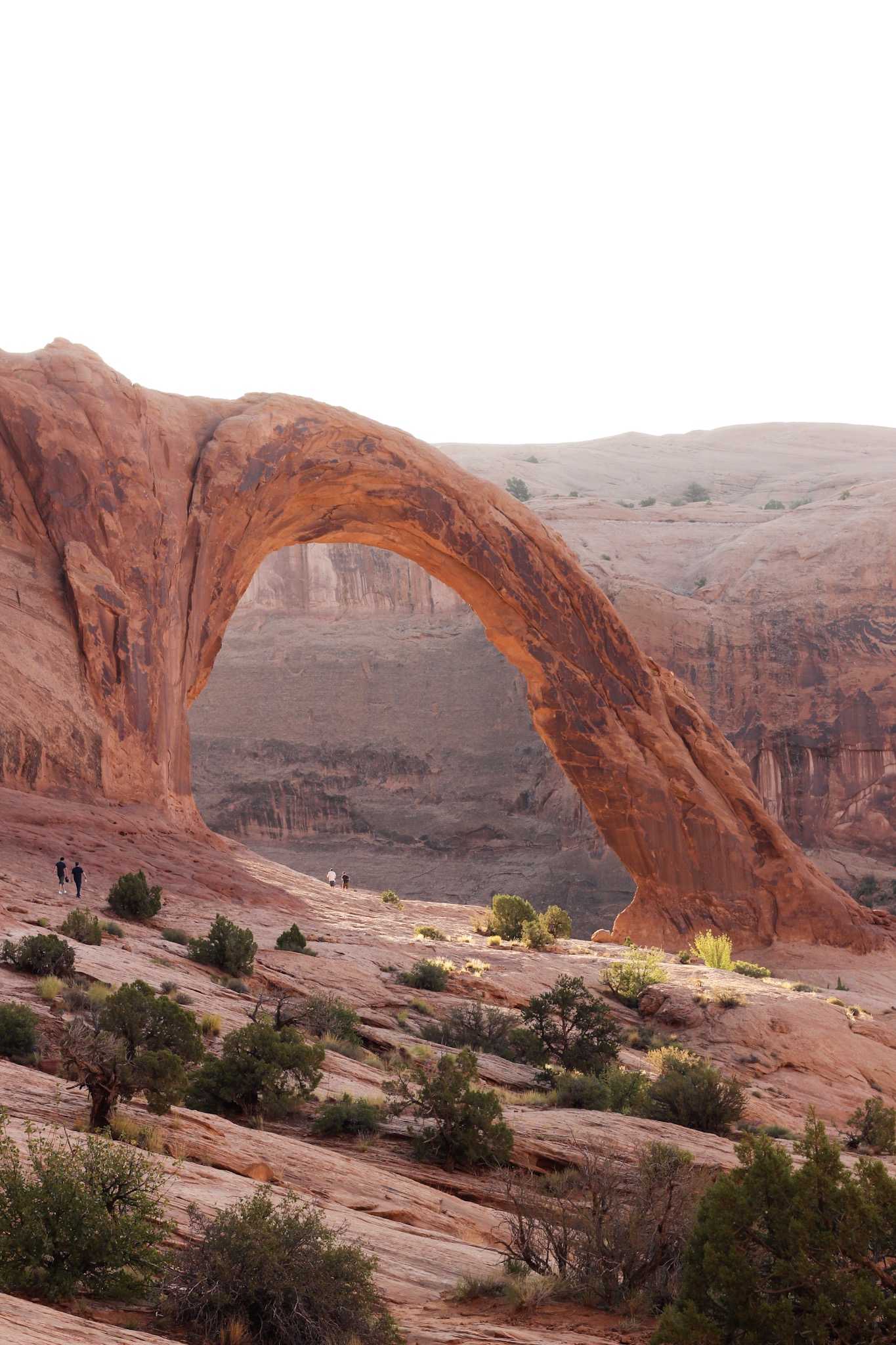
The hike that you see the really cool photo of the arch when looking up “Escalante National Monument” is a pretty long hike – and more officially called the Jacob Hamblin Arch. It requires some prep work such as a rope – we didn’t end up doing it because when I researched I honestly couldn’t figure it out if it was doable for a normal person, and it definitely is, but it’s a long day and you need a lot of water – you can look at sites such as AllTrails, The Outbound, and Champagne Escapades to learn more about it
Many hikes (all the ones listed below with the exception of Lower Calf Creek Falls) are located off of Hole-in-the-Rock Road. It’s a dirt road that is pretty well-maintained but make sure to check road conditions beforehand – weather can make it not-so-easy to get through, and 4WD is preferred. Our group had a Honda CRV and it did pretty well, but we went slow because it was similar to an Indiana Jones ride at time. Here is a resource for some further driving tips
A lot of the trails are sandy and can be tough – bring a lot of water to help you along; most hikes do not have refill areas, and if you’re going in the afternoon it can get pretty hot with little to no shade in many areas
Try to bring as minimal things as possible – especially going through the slot canyons! The larger your bag, the harder it is to get through
With that all being said, the scenery is beautiful and I’ve never had more fun on a hike, especially through the slot canyons!
More details about my hiking experience below…
The hikes
Lower Calf Creek Falls
Distance: 6 miles roundtrip
Time: 3-4 hours (for an average hiker)
This was our first hike and I’m so glad! We started early in the morning which was great for parking (by the time we left, there were cars parked all along the highway probably up to a mile away from the actual trailhead, while we found a spot very close to the trailhead).

When we started the hike, there’s a box that lifts up at the top and has some pamphlets as well as a sign-in sheet. If you don’t already know, I personally love tours because I get way more information than if I explored it myself, and the pamphlet provided is like a self-guided tour that makes the hike (in my opinion) even more fun. There are numbered markers along the way with more information about the surroundings. The one that was the coolest was marker #8 – it pointed out three large figures painted with red pigment across the canyon on the cliff wall. We would have completely missed this if we weren’t on the lookout. And, since no one actually knows what these figures represent, we had fun taking guesses.


The hike is pretty sandy, but it’s definitely the most lush out of the ones we went on. It was beautiful to see the reddish sand against the green plants and the wildflowers, along with the river of water that would pop up every now and then, especially as we got closer to the waterfall.
And once you hit that waterfall – definitely worth the hike! It’s 126 feet high and pictures don’t do it justice (per usual). It was also extremely cold. Sarah was the only one of us five brave enough to jump in (even though I wore my bathing suit underneath).

The area where the waterfall is is a nice area to sit and relax for awhile. I only wish I brought a hammock to hang up and then I could have stayed for hours. McKenzie also pointed out the moss that runs along the sides of the rocks and how they glistened in the sun. Absolutely stunning.

The five of us – Mollie, McKenzie, Sarah, me, and April
PS. If we had planned further in advance, camping here would have been really nice – great facilities, you’re on a little creek and it’s just a pretty place to be.
Zebra Slot Canyon
Distance: 5.2 miles roundtrip
Time: 3-4 hours (for an average hiker)
We didn’t have much of a break, aside from lunch, before we were on the road again to hike into Zebra Slot Canyon. Let me clarify that 6 miles was the longest hike I’d been on in awhile, so hiking another 5-ish miles was daunting.
Also, the actual slot canyon is at the very end of a no-shade, mostly sandy hike and the slot canyon itself is about .2 miles of the 5.2 mile hike. It also has water at the bottom of the slot, so I would recommend wearing some water shoes and you’ll most likely need to leave backpacks at the entrance because it is so narrow. Check comments on AllTrails to see updated conditions. Another awesome resource I used was Earth Trekkers – there’s one tricky part of the trail that they point out – basically stay to the left.

This is the only shaded part of the hike – also depending on what time of day you’re going. I kind of wish we had done this first thing in the morning because we went later in the afternoon and it was so hot.
But these formations were really cool to walk through.

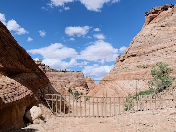
The gate down below, I’m guessing, is a cattle gate. But the unique thing is that you push it up instead of to the side. Kind of fun and a good trail marker along the way.
We made it to the slot canyon! The water was about ankle/calf deep so I took off my shoes and went barefoot. I really wished I had water shoes, especially because there are some tumbleweeds that get into the slot and so the ground isn’t totally smooth with a few small rocks.


Maybe part of the reason I don’t have as much appreciation for this hike (aside from being completely exhausted, thirsty, and hot) is that I made it only a few hundred feet into the slot canyon before I turned around! When they say that this canyon is narrow – it’s narrow. Below are some photos of me where I got stuck – not actually stuck, but just where I couldn’t go past.
I watched in awe as some people were able to sort of boulder up and over this part, but 1) I was tired, and just trying to climb even a little above was so hard, and 2) I was very afraid of having to do this on the way back and not being able to. Plus, I’m not claustrophobic, but I was getting anxious and feeling trapped even thinking about #2.


I told my friends to go on without me, and went back and made some more friends with people from Colorado whose dog didn’t want to go through.
My friends said that there were some other parts that were maybe even more narrow than that first part, so I was especially glad I didn’t go. I also heard people were kind of angry because of the jam that happened with so many people trying to get out and so many trying to get in without much place to pass.
For those that are interested in seeing the reason why it’s named “Zebra,” you can see the stripes at the end of the slot where April is standing below. It does look pretty cool!

Peek-a-boo slot canyon
Distance: 4.5 miles roundtrip (including Spooky, not including Dry Fork Narrows)
Time: 3-4 hours (for an average hiker)
And now onto my favorite hikes, I think because they were so different from any other hike I’ve experienced elsewhere. These slot canyons felt like a naturally formed playground to explore and I loved it!
I was initially a little confused about Peek-a-Boo and Spooky because they’re often grouped together. That’s because if you’re going to do one, you might as well do the other since they’re only half a mile apart. In fact, when we went, because of the virus, the park ranger gave us a map and said we sort of had to go through both because they were trying to have people go in one direction. There wasn’t really a way for rangers to make sure that happened, but a strong suggestion, and I think made the experience better.
The hike starts out fairly easy, just wandering around a beautiful trail. The sand is pretty hard packed here and not bad.

You get to a rocky sort of cliff that you climb down (not steep) that has little trail markers set up. Then there’s a sort of steeper part that is fine, but boy when you’re on the way back is tough.
There was a little more shade on this hike than the Zebra slot, especially once you’re in the slot canyons themselves. There’s also an option to go on another trail (Dry Fork Narrows) but we didn’t do that.


You could choose to go to Spooky first, but I recommend starting with Peek-a-Boo – the photo below shows the only climb up (it’s 12 feet) and it looks hard at first, but it’s not so bad, while Spooky would be much easier to go down than up.
I saw somewhere that dogs aren’t technically allowed in the slots, although I did see a few. I think they could do it, but I wouldn’t recommend it. Watching this one try to make it up was a little scary (it did make it eventually).

Once you climb up, it’s just a lot of fun from there. If I were to go back, I would only bring water and a very small backpack. But other than that, looking at the formations and climbing through them was so much fun!


Spooky Gulch
Once you get through Peek-a-Boo, it’s a short walk to the beginning of Spooky. The reason it’s called Spooky is because it’s narrower than Peek-a-Boo, often making it darker since not as much light comes through. This also makes it cooler which is a nice break from the sun.
I was really nervous about this one because it says that it’s even more narrow than Zebra, and since I couldn’t get through Zebra, I was afraid of having to go all the way back. Fortunately, I was totally good!

Mollie looking up the Spooky Gulch canyon
I also liked that at certain points you had to climb down to break things up a bit – there was a small rope at one point to use to get down and it worked great.


Climbing through these slots felt like figuring out a puzzle sometimes on how to best contort your body to get down or get through them. I honestly can’t say enough about how much I enjoyed this experience.
Devil's Garden
If you’re going to Peek-a-Boo/Spooky, you might as well stop to see Devil’s Garden. It’s a hike if you want to make it one, but it’s also a cool place to have a meal, relax and check out the formations.
It reminded me in a lot of ways of Goblin Valley, but a little taller.

The hikes through Peek-a-Boo/Spooky took much longer than expected, so we were all pretty tired and hungry. I was trying to avoid walking on the newly-formed blisters on my feet. The previous day’s mileage was also being felt at this point, too.
Accordingly, we didn’t stay too long at Devil’s Garden, but did take enough time to walk around and explore a little bit.


Mollie, Sarah and April even went on this little bridge between rocks.

Meanwhile, I was very happy to just sit in the shade and be the designated photographer.


Escalante petrified forest state park
For our last day in Escalante, we wanted a hike that was very easy and quick before our car drive back to Provo. So we chose the very nearby Escalante Petrified Forest State Park. It’s also a camping site with a reservoir that offers canoeing, kayaking or paddle boarding if you want to make more of a day of it.
We paid $10 for a one-vehicle entry, and took the one mile loop hike to see the petrified wood (there’s also a .75 mile Trail of Sleeping Rainbows extension if you’re feeling up for it).
I was supremely excited that, like Lower Calf Creek Falls, there were trail guides available with markers along the way. Petrified wood is surprisingly beautiful with so many colors formed as it ages over millions of years.


It was honestly the perfect low-key, but still fun, way to end a great trip. Thanks to these incredible women for making it happen!